WEATHER MODEL BREAKING NEWS BULLETIN JUNE 12
This statement is being sent to out to let you know of significant changes in the new European weather model. The 12Z Monday European has now completed its run and while it is similar over the next 7 days to the GFS it has a significant change in DAY 8-9-10. The new European model is significantly wetter over the very areas where the GFS is significantly drier.
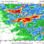
The new European model has significant rains over the southern half of Iowa … central and northern Illinois … most of Indiana and Ohio … with rainfall amounts of 1-4″/ 25-100mm with a few small areas of 5″/125mm embedded in the general rain area. It has a second rainy area over Minnesota and Wisconsin where again the rainfall amounts range from 1-4″/ 25-100mm with a few locally higher amounts.

In other words the main difference with the European vs. the GFS is that after day 7 … the GFS model drives the cold front Deeper into the Deep South and the East Coast — which means LESS rain for the Midwest and Upper Plains. The European model stalls the front apparently over the Midwest which provides for more rain in the week 2 forecast for all of the Midwest – but NOT the Upper Plains,
Obviously this increases the risk of seeing more rain in the second half of JUNE 2017 over all of the Midwest.
